CHARLOTTE, N.C. —
Sunday
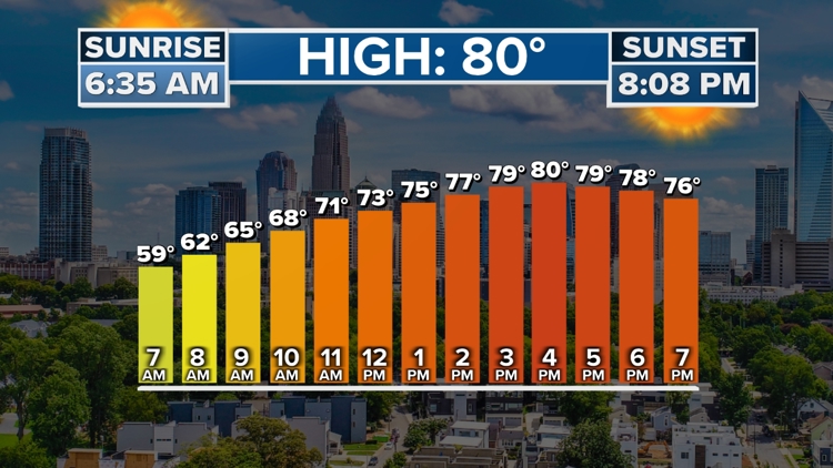
A warming trend begins today as temperatures return to the low 80s. Expect more sunshine than cloud cover throughout the day with a light, southwesterly breeze.
The southwest wind pumps in warmth and muggier air but high pressure will suppress any storm development. Clear sky conditions overnight will allow for temperatures to drop to the upper 50s.
Big Warm Up
May is coming in hot with highs nearing 90 degrees by mid-late week! This is around 10 - 15 degrees above average.
Before we get there, a few spotty storms are possible on Tuesday afternoon as a cold front approaches from the west. It never pushes through, remaining stationary, and bringing those few storms and more clouds.
After that, our next chance for rain and storms isn't until Friday and into next weekend.
Pollen Report
Tree pollen is the main cause of high pollen levels for late April before these numbers begin to decrease by mid-May.
WCNC Charlotte’s Weather IQ YouTube channel gives detailed explainers from the WCNC Charlotte meteorologists to help you learn and understand weather, climate and science. Watch previous stories where you can raise your Weather IQ in the YouTube playlist below and subscribe to get updated when new videos are uploaded.
Stay connected to the WCNC Charlotte Weather Team:
Contact Brad Panovich at bpanovich@wcnc.com or follow him on Facebook, X and Instagram.
Contact Larry Sprinkle at lsprinkle@wcnc.com and follow him on Facebook, X and Instagram.
Contact Chris Mulcahy at cmulcahy@wcnc.com and follow him on Facebook, X, Instagram, and TikTok.
Contact Brittany Van Voorhees at bvanvoorhe@wcnc.com and follow her on Facebook, X and Instagram.
Contact KJ Jacobs at kjacobs3@wcnc.com and follow him on Facebook, X and Instagram.